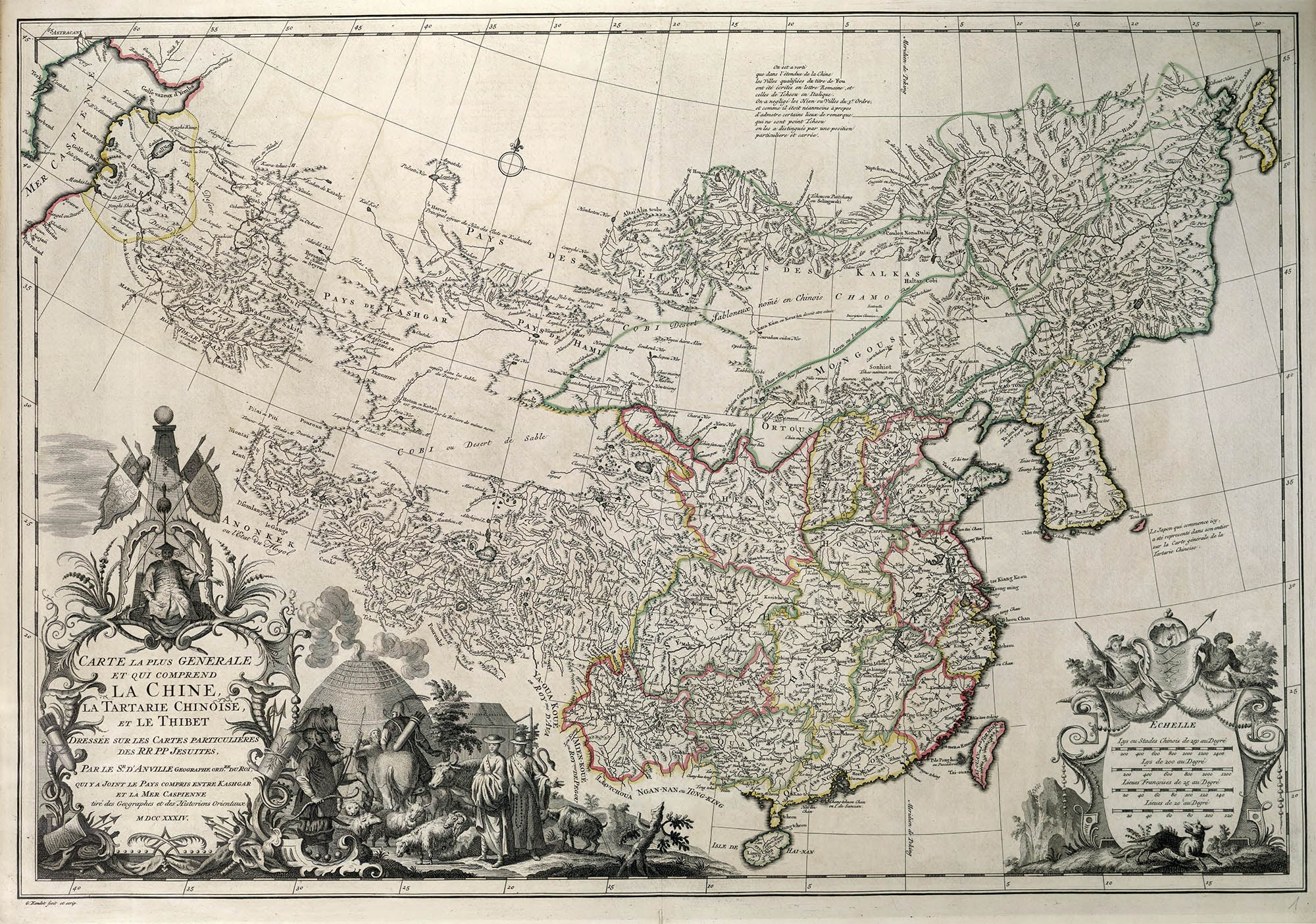
Carte La Tartarie Chinoise et Le Tibet, 1733. From ref. 1
47
Everest
Part I – The Early Maps
This eighteenth-century French map of China and Tibet, from Jean Baptiste Bourguignon d’Anville’s Nouvel Atlas de Chine,1 was the first European map of China. It was also the first European map to include the Himalayan peak that would be later known as Mount Everest.
Mount Everest, AKA सगरमाथा (Sagarmāthā), ཇོ་མོ་གླང་མ (Chomolungma or Qomolangma) or 珠穆朗玛峰 (Zhūmùlǎngmǎ), is located on the border of Nepal and Tibet in the Khumbu region of the Mahalangur Himal subrange of the Himalayas, or more specifically, at 27°59′17″N 86°55′31″E. At 29,028 ± 7 ft (8848 m) it is the tallest mountain in the world. Since its “discovery” in the 19th century it has received more cartographic interest than perhaps any other place on Earth.2
The first mention of Mount Everest, by the name Chomolungma or Chomo-Kankar was, and I can’t imagine this is a surprise, from Tibetian sources as early as 750 AD. The earliest Western references to Everest date to the early 18th century. Between 1708–1716 Jesuit missionaries, under 康熙帝 (Emperor Kangxi or K’ang-hsi), performed the first survey of China and produced the Huang Yü Chüang T’u (Royal Map of the Chinese Empire) in 1718. This map included a mountain group named Jumu Lungma that was in the position of Everest:
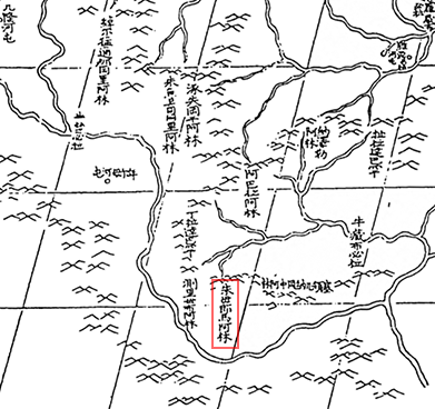
Detail, Huang Yü Chüang T’u. Jumu Lingma is outlined in red
Although the Emperor allowed few people in China to see his map he did allow the Jesuits to “directly or otherwise transmit the survey results to Paris.” And the Jesuits did: the surveys were used as the basis of d’Anville’s 1733 Nouvel Atlas de Chine, which included Everest (on two separate maps, and twice on one map) by the French name of M. Tchoumour:
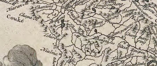
Detail, Carte La Tartarie Chinoise et Le Tibet. M. Tchoumour is roughly centered in the detail
Jumu Lungma or Mount Tchoumour would remain just another obscure Himalayan peak until the Great Trigonomical Survey of India.
The GTS, part of the British Survey of India, began the triangulation of India in 1803. Not only did the Survey completely map the subcontinent and perform the longest surface measurement of the Earth ever attempted, the so-called Great Arc, but it also measured some 70 distant Himalayan peaks.
In 1846, by the time Survey reached the foothills of the Himalayas, Andrew Waugh, the GTS Surveyor General, identified a peak near Kangchenjunga, then considered the largest mountain in the world, which he named peak XV.3 Further calculations suggested that it could very well be taller than Kangchenjunga.
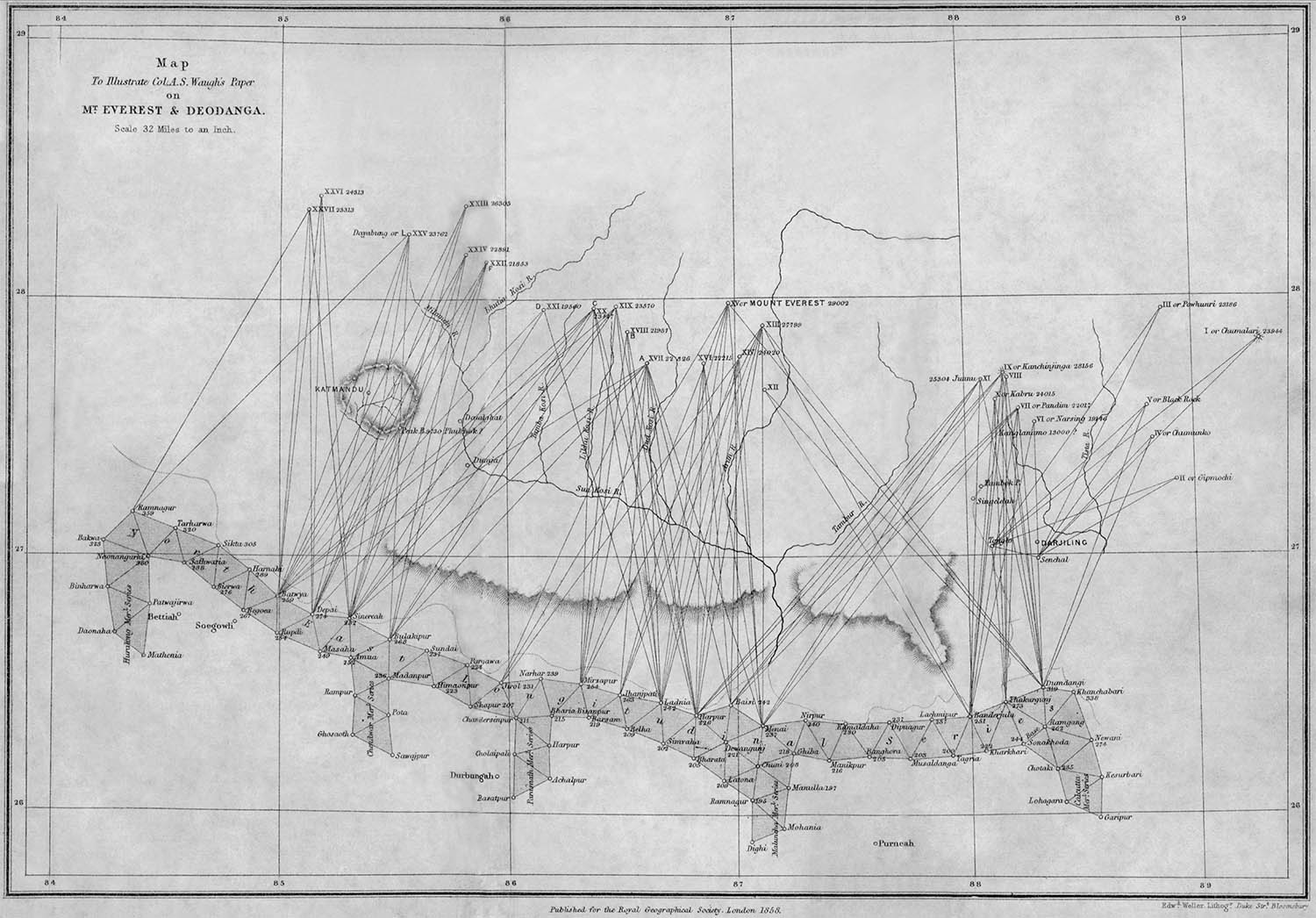
Waugh’s triangulation map of the Himalayas, 1862. From ref. 4
Because Nepal, Sikkim and Tibet were closed to foreigners it took several more sightings from the Himalayan foothills in India between 1849–1850 and a fair amount of, well, trigonometry, before Waugh wrote to the President of the Royal Geographical Society, on 1 Mar 1856, and announced that peak XV, calculated to be 29,002 ft, was the highest mountain in the world.4 In a controversial move he proposed naming peak XV Mount Everest, after his GTS predecessor, rather than a local name. Despite protestations, including Col. George Everest himself, the RGS officially adopted his suggestion.5
Waugh attempted to get surveyors into Nepal to clarify his findings, but to no avail. For the next 60 years Nepal remained closed to foreigners. Aside from a few covert surveyors (the so-called Pundits) the Everest region would remain Terra Incognita.
After WWI, the RGS and the Alpine club finally received permission from the Dalai Lama to enter Tibet and for the next 30 years the British would pretty much monopolize the mountain. Their first expedition, a six month reconnaissance in 1921, was the first time a westerner ever saw the mountain. The expedition team provided a surprisingly good photographic record, as well as several surveys and maps:6
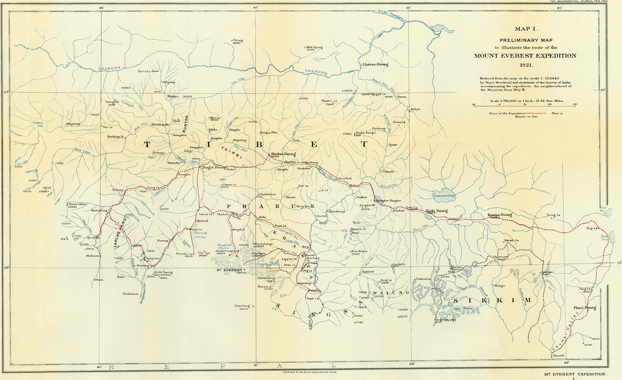
The Milne map, Feb 1922. From ref. 6
The topographical map, drawn by H. F. Milne from panoramic photographs gave at least a general view of the Tibetan side of the mountain, but as Howard-Bury notes “The topography west of the mountain...was very doubtful.”7 It was the map used for the 1922 and 1924 summit attempts.
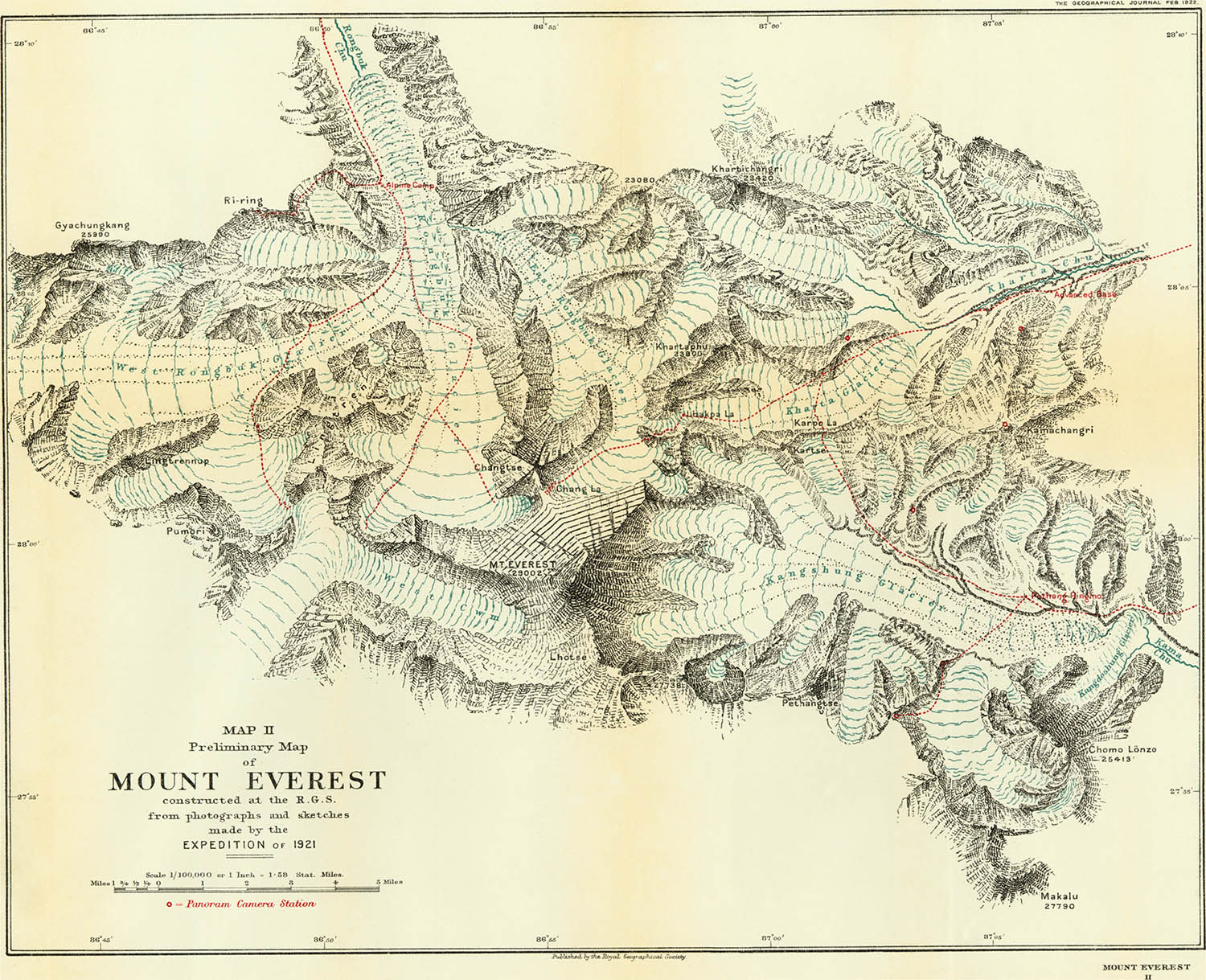
In 1925 the RGS prepared a new map, based mostly on the 1921 surveys and photos, for their forthcoming book about the 1924 expedition.8 The Wheeler map, drawn at 1:63,360 by the noted Swiss cartographer Charles Jacot-Guillarmod was easily the best Everest map to date. Jacot-Guillarmod’s command of Swiss-school relief techniques compares favorably to even the most current maps of Everest:
Detail, Mount Everest & the Group of Chomo Lungma, 1925. From ref. 8
In 1933 an aerial reconnaissance mission provided both vertical and horizontal photographs, including the first images of the Nepal (South) side of the mountain. In 1935 a small expedition was mounted. Although it arrived too late in the season for a summit attempt, the surveyor Michael Splendor completed a photogrammetrical survey, including a new map, of the North Face.9

Telephoto with added contours from the North Col, 1935. From ref. 9

The Splendor map, 1935. From ref. 9
The Splendor map, while perhaps not as pretty as some others, was the first to indicate accurate heights and distances. It was used on both the 1936 and 1938 summit attempts.
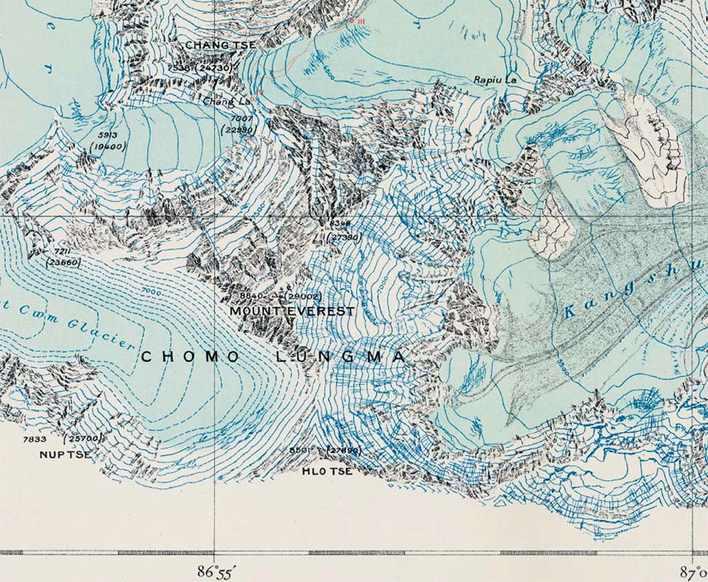
A. R. Hinks, mathematician, cartographer and secretary of the RGS, combined the information from the 1933 aerial photos and the 1935 Splendor photos to create a composite map of Everest in 1945:

Detail, Hinks-Milne map, 1952. From ref. 10
The map, beautifully drawn by Milne, included remarkably accurate spot heights for the South face. This information would have surely come in handy less then a decade later, however the map was largely forgotten until the 1990s when Michael Ward found it searching through the RGS archives.
1. D’Anville, Jean Baptiste. Nouvel Atlas de la Chine, de la Tartarie Chinoise, et du Thibet. La Haye: Henri Scheurleer, 1737. The entire book, including the map shown here, is online at the LOC’s Meeting of Frontiers site.
2. For an overview of the mapping see: Ward. M.P. Mapping Everest. Cartographic Journal 1994 Jun;31(1): 33–44. For more detail see: Ward, Michael. Everest: A Thousand Years of Exploration. Glasgow: The Ernest Press, 2003.
Over the last 50 years there has been a ridiculous amount of written material on Everest. Perhaps the best single volume is Unsworth, Walt. Everest - The Mountaineering History. Seattle, WA: The Mountaineers, 2000. For an excellent annotated bibliography see Bill Buxton’s From First Sight to Summit.
3. There are 14 peaks over 8000m: 1. Everest 8848m; 2. K2 8611m; 3. Kangchenjunga 8586m; 4. Lhotse 8516m; 5. Makalu 8462m; 6. Cho Oyu 8201m; 7. Dhaulagiri 8167m; 8. Manaslu 8156m; 9. Nanga Parbat 8126m; 10. Annapurna 8091m; 11. Gasherbrum I 8080m; 12. Broad Peak 8051m; 13. Gasherbrum II 8035m; 14. Shishapangma 8013m. There are 158 peaks between 7000–8000m. Your narrator has climbed exactly none of these peaks. He has, however, occasionally climbed several flights of stairs.
4. A. S. Waugh, letter in Proceedings of the Royal Geographical Society 1855/57;1: 345–47.
5. Waugh wrote: “But here is a mountain, most probably the highest in the world, without any local name that we can discover, whose native appellation, if it has any, will not very likely be ascertained until we are allowed to penetrate into Nepal.” Waugh, A.S. Mount Everest and Deodanga. Proceedings of the Royal Geographical Society 1857/58;2:101–115. The name Mount Everest continues to be a rather contentious issue to this day.
6. Howard-Bury, C.K. The Mount Everest Expedition. The Geographical Journal. 1922 Feb;59(2): 81–99. An expanded account is in: Howard-Bury, C. K. Mount Everest The Reconnaissance, 1921. London: Arnold Edward & Co, 1922, which is available online at Google Books.
7. Howard-Bury, C.K. The Mount Everest Maps and Photographs Source. The Geographical Journal. 1922 Feb;59(2): 131–137.
8. Feldman, Hans-Uri. Charles Jacot-Guillarmod - One of the Pioneers of the Swiss Style of Rock Representation. In: Proceedings of the 6th ICA Mountain Cartography Workshop, 11–15 February 2008, Lenk, Switzerland. 41–47. Both the paper and the presentation are available online. The map was included as a 4-color 50 × 36cm lithograph foldout in: Norton, E.F. The Fight for Everest 1924. London: Edward Arnold & Co, 1925. Jacot-Guillarmod died of a stroke just weeks before the map, perhaps his most significant work, was published.
9. Shipton, Eric. The Mount Everest Reconnaissance. The Geographical Journal. 1936 Feb;87(2): 98–107.
10. Ward. M.P., Clark, P.K. Everest, 1951: Cartographic and Photographic Evidence of a New Route from Nepal. The Geographical Journal. 1992 Mar;158(1): 47–56.
29 Nov 2009, updated 22 Apr 2012 ‧ Cartography