Detail, Isometrical Drawing of the Gettysburg Battle-Field, 1863. LOC
125
Gettysburg
The Bachelder, Cope and Warren Maps
After Lee’s unlikely victory at Chancellorsville in May 1863 he led his Confederate Army of Northern Virginia through the Shenandoah Valley and across the Potomac with the intention of bringing the war to Pennsylvania.
Neither side had particularly accurate maps of enemy territory so Lee’s advance scouts, under the guise of map peddlers, confiscated every Pennsylvania county map they could find, especially of Franklin, Cumberland, and Adams counties.1 This landowners map published by Griffin Hopkins in 1858 was the most detailed map of Adams county available at the time. It would turn out the be especially useful to Lee:

Map of Adams Co., Pennsylvania, 1858. LOC
Meade’s Union Army of the Potomac followed Lee into Pennsylvania and on the morning of Wednesday, 1 Jul 1863 elements of both armies met in Gettysburg. Although neither commander wanted an engagement here circumstances would dictate otherwise. As the battle escalated both generals urgently concentrated their armies on the town – nearly 170,000 troops by Thursday afternoon. Over the next three days fierce fighting would occur in places now etched into history: Culp’s Hill, McPherson Ridge, the Railroad Cut, Devil’s Den, Little Round Top, the Wheatfield, the Peach Orchard and Cemetery Ridge.
Despite heavy losses over the first two days Meade’s line had held. On Friday afternoon Lee tried one last desperate gambit, a massive cannonade and Napoleonic assault against the Union center – Pickett’s Charge. Although at one point the Rebels breached the Union line (“the high water-mark of the Confederacy”) the charge was driven back. Lee had been defeated and the next day he began the retreat back to Virginia.
It was the bloodiest battle in American history – more than 51,000 casualties including some 7000 killed. Lee had lost a third of his army and the Confederacy would never recover.2

Timothy O’Sullivan, A Harvest of Death, ca.5 Jul 1863. LOC
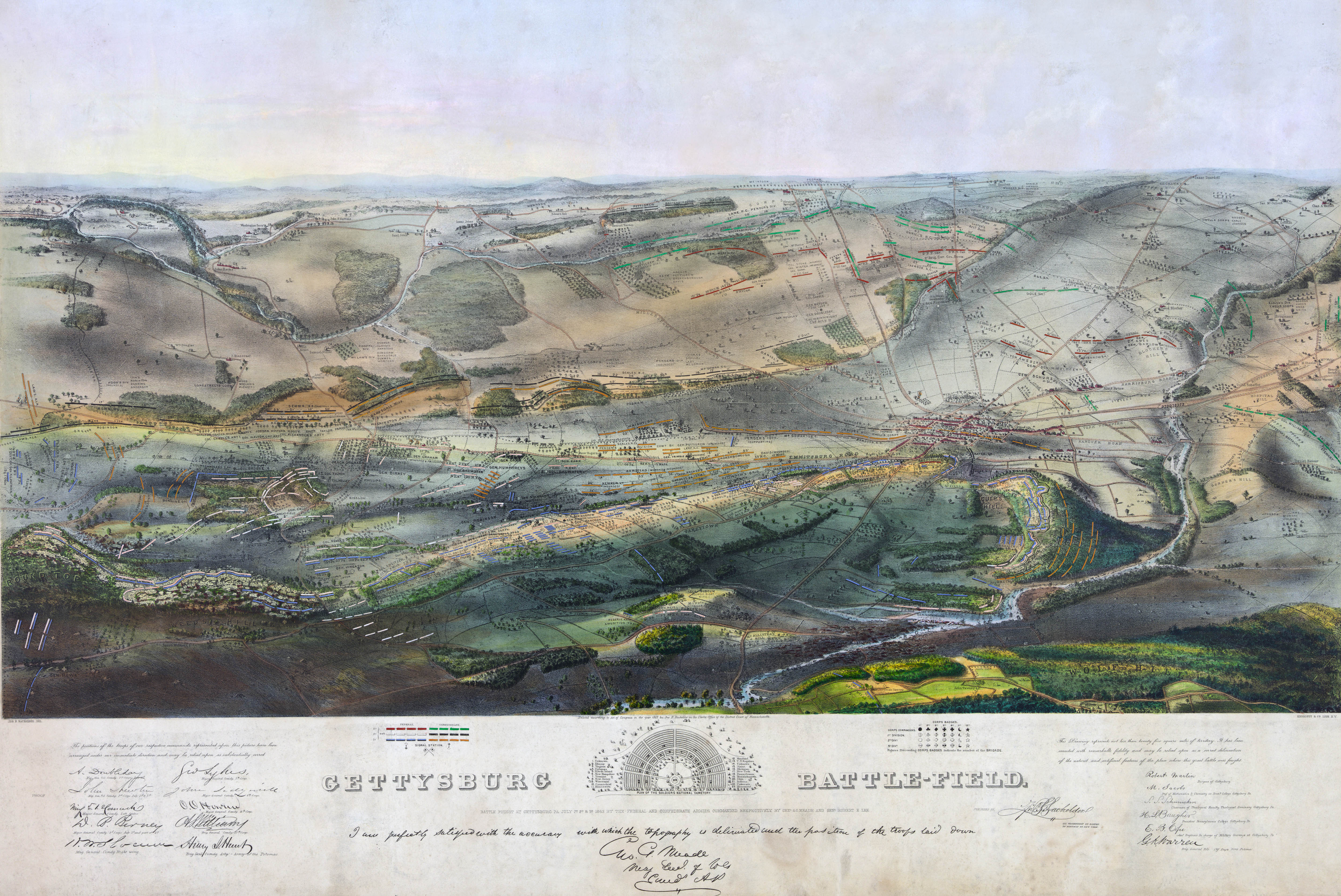
The Boston artist and lithographer John Bachelder began following the Army of the Potomac in early 1862 sketching battles. He arrived at Gettysburg within the week and spent 84 days on site researching the battle, including surveying the battlefield, visiting field hospitals and interviewing both Confederate and Union officers and soldiers. By the end of the year he published his spectacular bird’s-eye map (above) which showed the troop positions on all three days of the battle.3 The final map was endorsed by General Meade himself. Winfield Scott was so impressed that he introduced Bachelder to Presiden Lincoln. The map was so popular than he was soon deluged with unsolicited first-hand accounts. He became the first Gettysburg historian.
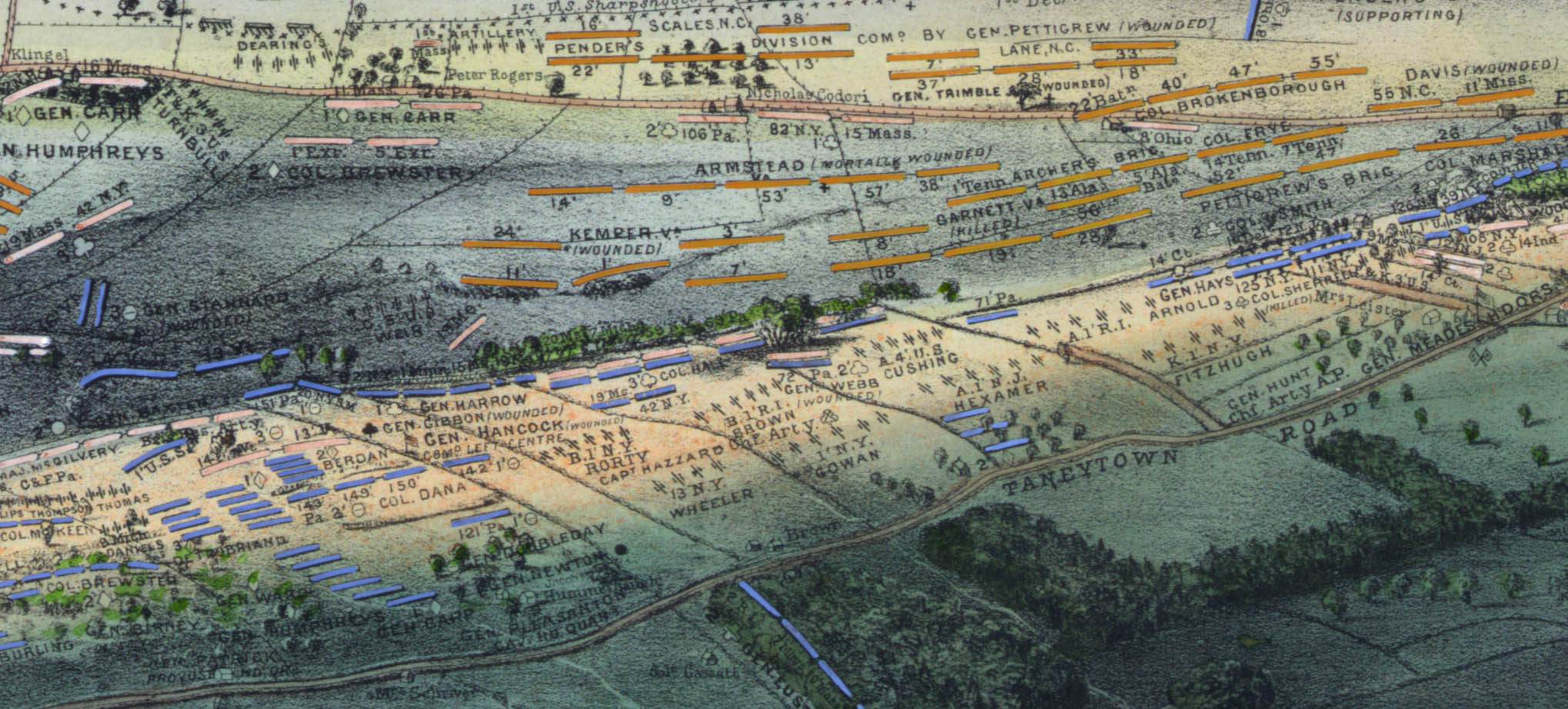
Here is a detail from Pickett’s Charge centered around “The Angle:”
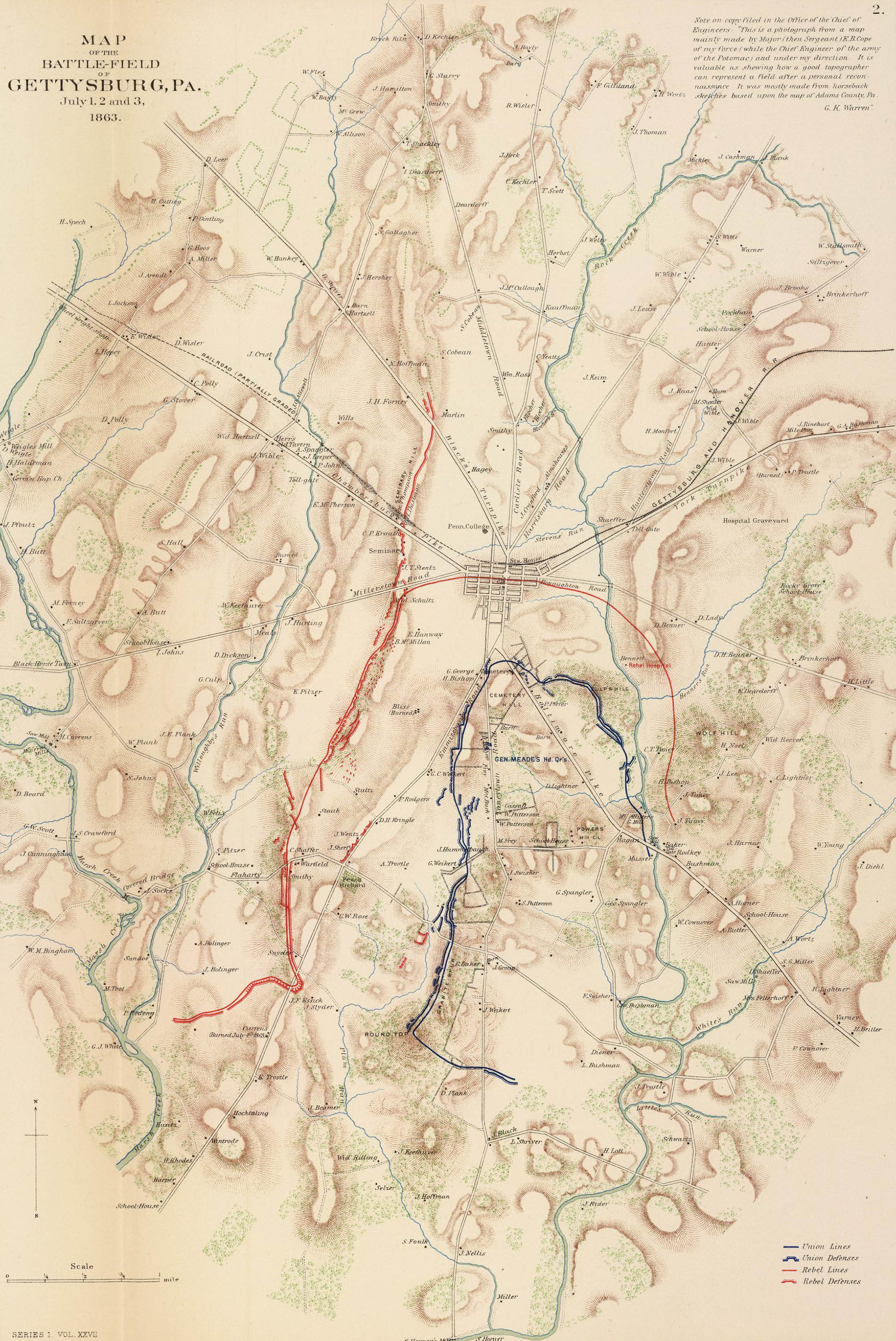
In Oct 1863 Emmor Cope,4 a sergeant with Brev. Maj. Gen. Gouverneur K. Warren’s Topographical Engineers made a ”cursory reconnaissance sketch” on horseback of the battlefield and prepared this map which was reprinted in the Atlas to Accompany the Official Records of the Union and Confederate Armies: 5
Map of the Battle-field of Gettysburg, Pa. Rumsey Collection
After the war Gen. Warren returned to Gettysburg with more time and resources. Between 21 Oct 1868 – 23 Oct 1869 his battalion, under 1st Lt. William Chase, performed the first proper survey of the battlefield. The result was a massive, but unpublished, 13×11 foot 1:2400 scale map in 20 sections. Although historians consider it to be a better map of 1868 Gettysburg than of 1863 Gettysburg, it was still the most important historical survey done. Here are a few of the original sheets:
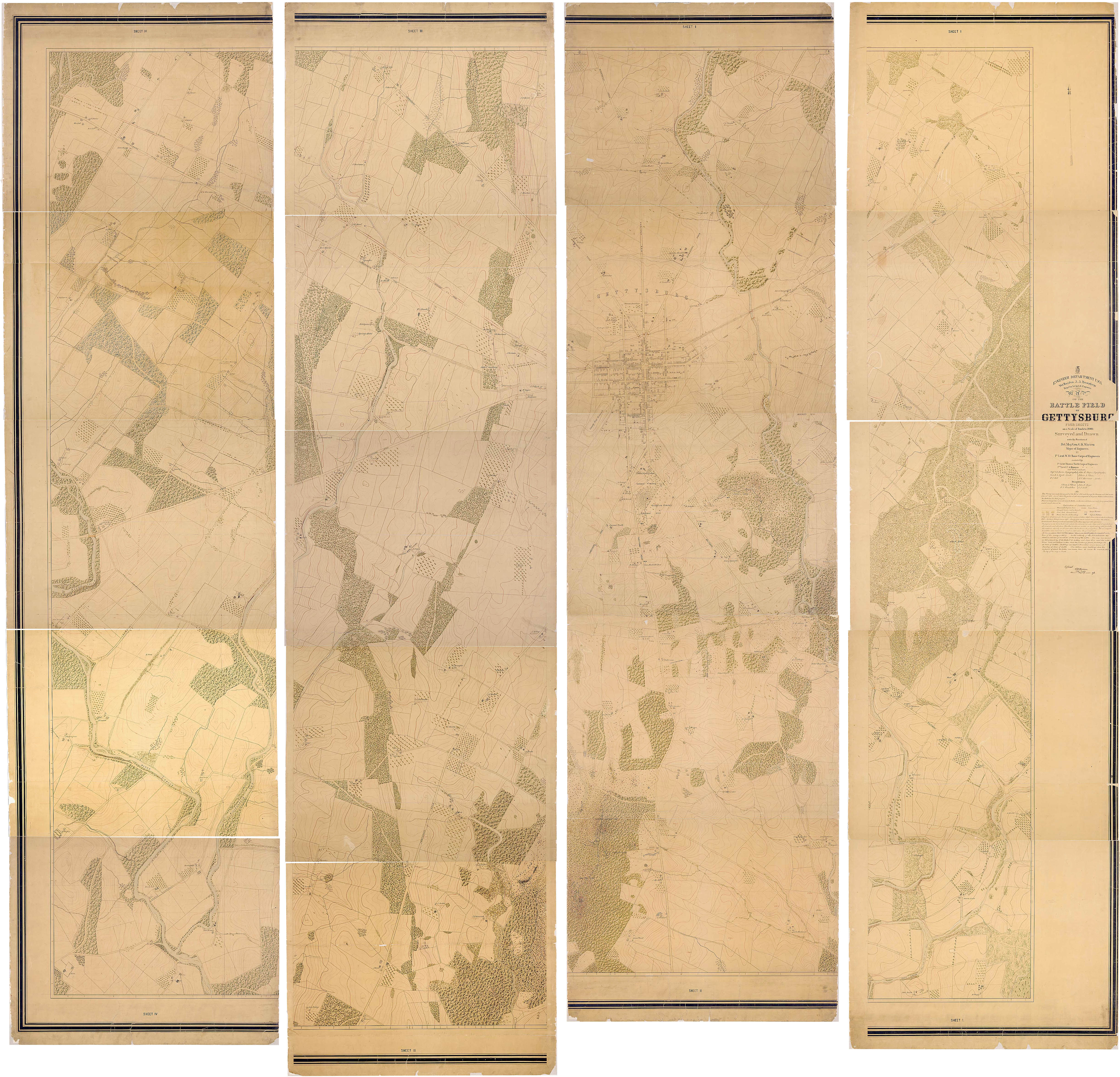
Map of the Battle-field of Gettysburg, 1868–06/1873. National Archives 305571
A smaller version of the Warren map was published in the OR Atlas:

Map of the Battle-field of Gettysburg. Rumsey Collection
In 1876 Bachelder prepared a series of maps superimposing the daily troop positions over Warren’s survey.6 In 1880 the War Department contracted Bachelder to write a history of the battle and as part of the project he broke down his daily maps into 28 “hourly” maps. Although his history was never published the maps have become classics. More than a century later they remain perhaps the most authoritative maps of the battle ever published. Here are the daily maps:
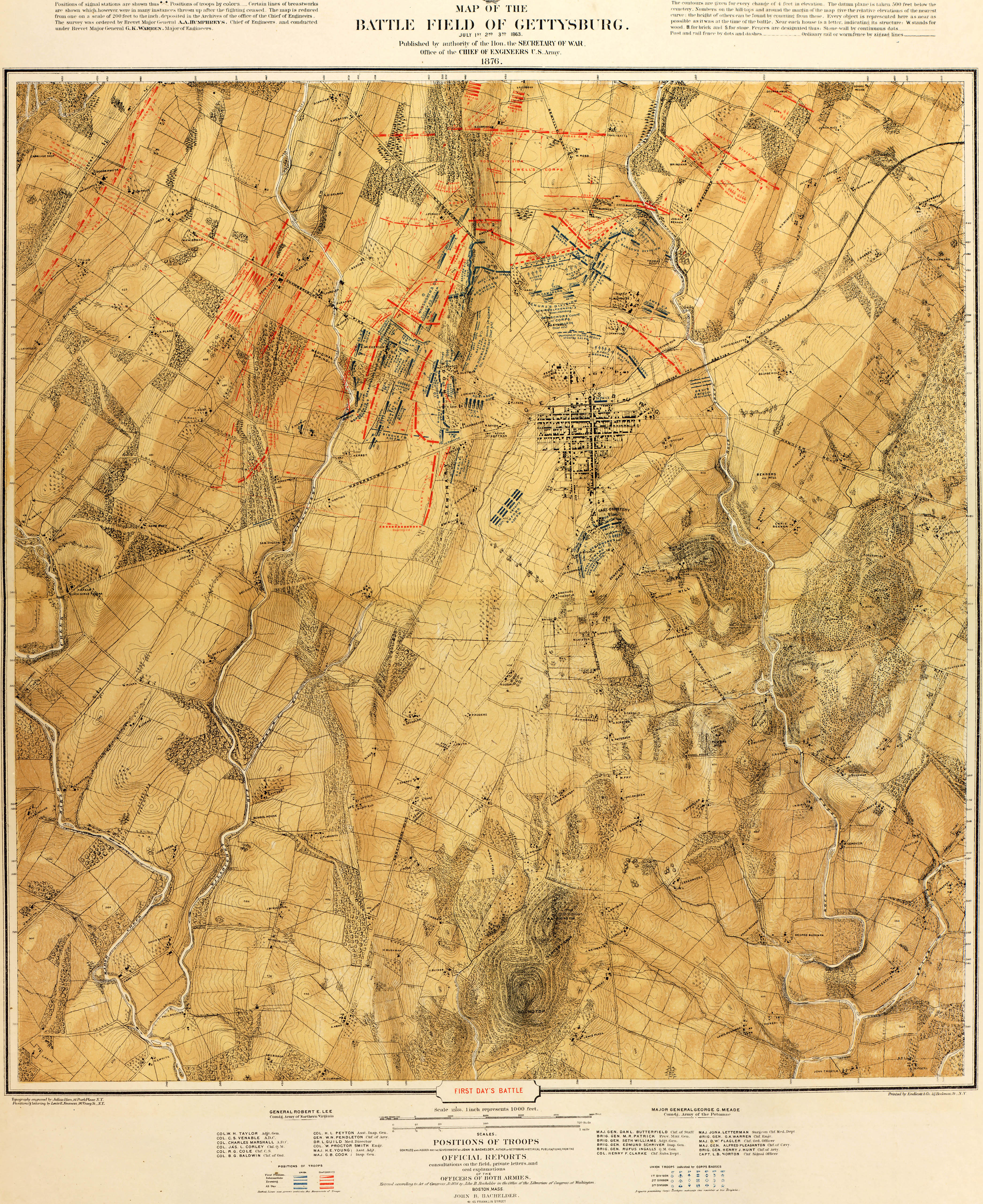


First Day’s Battle (top), Second Day’s Battle, Third Day’s Battle (bottom). Big Map Blog
As early as August 1863 the State of Pennsylvania began buying land parcels to preserve the battlefield. Their first project was to properly reinter hastily buried Union soldiers. The Soldier’s National Cemetery, designed by the landscape architect William Saunders, was dedicated on 19 Nov 1863. Lincoln’s “few, appropriate remarks” would become the most eloquent speech in American history.
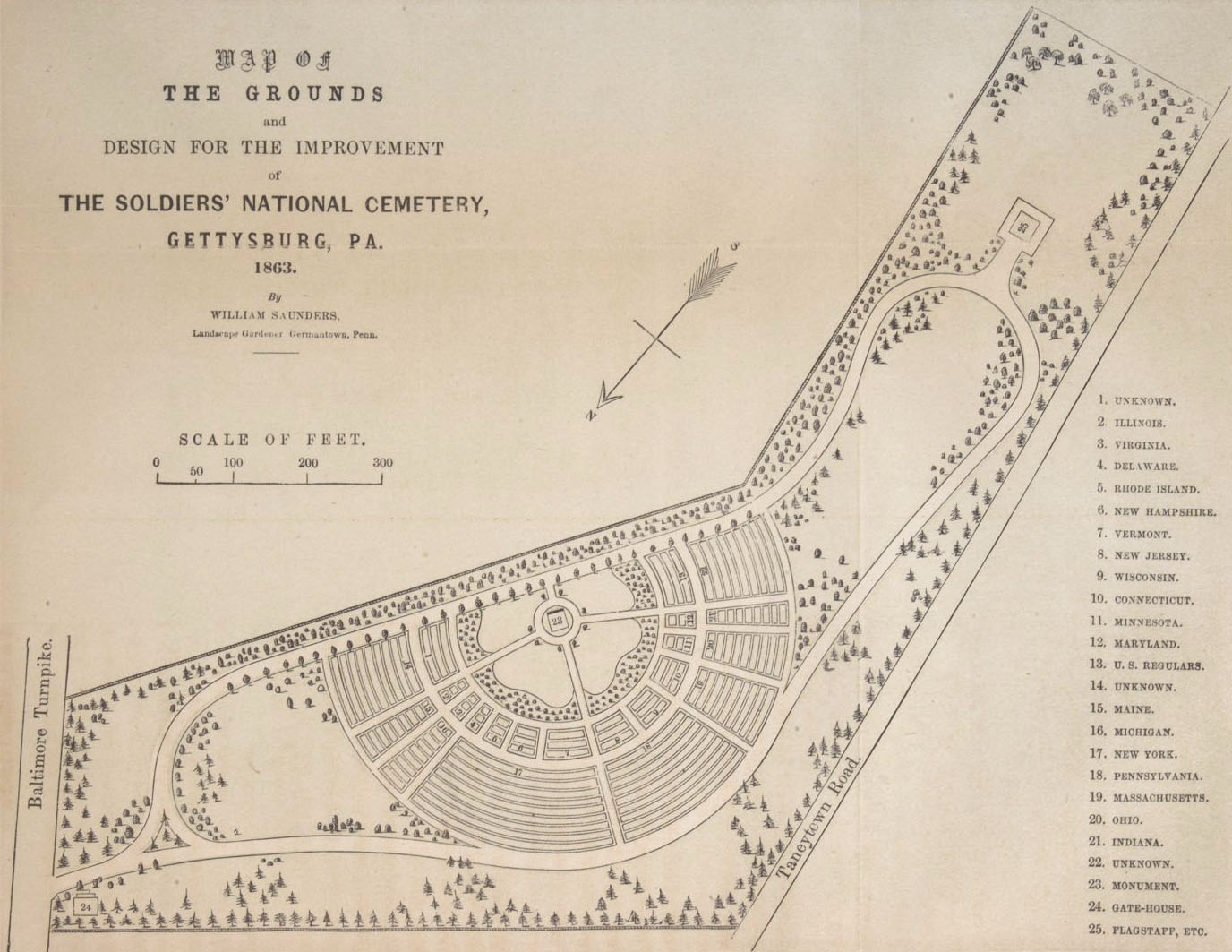
The Saunders Plan, 1863. Cornell
In 1864 the Gettysburg Battlefield Memorial Association (GBMA) was established and over the years continued to acquire land and preserve the battlefield. Between 1883–1887 John Bachelder was their Superintendent of Tablets and Legends.
In 1894 the GBMA’s holdings – now some 600 acres – were turned over to the War Department which designated Gettysburg as a National Military Park. One of their first appointments was none other than Emmor Cope as Chief Engineer. Here is his 1904 map showing the location of Pennsylvanian monuments in the Park:

Battle Field of Gettysburg. Simmons Games
Bachelder, perhaps more than anyone else, was responsable for the placement of monuments and markers and Cope oversaw much of the parks infrastructure. Some 100 years later their efforts are still clearly apparent. Not a bad legacy for two mapmakers.
1. For a general overview of Civil War mapping see: Stephenson, Richard, Civil War Maps: An Annotated List of Maps and Atlases in the Library of Congress, 2nd ed. Washington: Library of Congress, 1989 (online). For more about surveying the Gettysburg battlefield see: Musselman, Curt. “In the Footsteps of the Topographic Engineers at Gettysburg.” Professional Surveyor. 2011 Dec 31(12), (online).
2. There have been so many books written about Gettysburg that it is rather difficult to present a comprehensive bibliography. If it helps you humble narrator can recommend Sears, Stephen. Gettysburg. New York: Houghton Mifflin, 2003, which is, perhaps the best current single-volume history of the battle. If your really interested consider the classic Coddington, Edward. The Gettysburg Campaign: A Study in Command. New York: Scribner, 1968.
3. The 10-page Key to Bachelder’s Isometrical Drawing of the Gettysburg Battle-field, with a Brief Description of the Battle (Boston, 1864) is available at the Internet Archive.
4. For a wonderfully detailed biography of Cope see: Schaefer, Thomas. “If You Seek His Monument, Look Around: E.B. Cope and the Gettysburg National Military Park.” A Gettysburg Seminar Paper at nps.gov.
5. The War of the Rebellion: a Compilation of the Official Records of the Union and Confederate Armies (or just the OR) was published in 128 volumes between 1880-1894. The 175-plate Atlas to Accompany the Official Records of the Union and Confederate Armies was published in 1895. A searchable copy of the OR is available at Cornell’s Making of America. A complete copy of the Atlas is available at Rumsey.
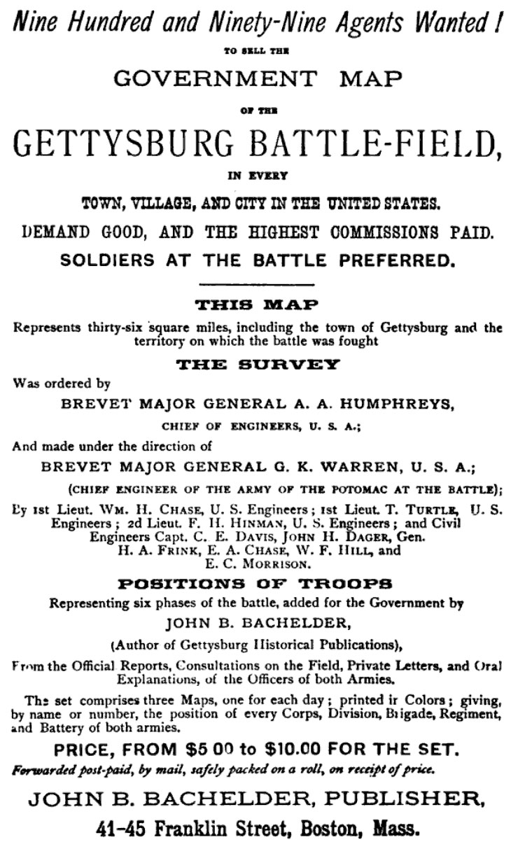
6. If you were interested in the maps at the time Bachelder had a business proposition for you. This ad appeared in his popular guide Gettysburg: What to See, and How to See It (Boston, 1873):
1 Jul 2012 ‧ Cartography