Detail, Rio Colorado of the West. 1858. LOC
91
The Grand Canyon
Part I – the Colorado River Maps
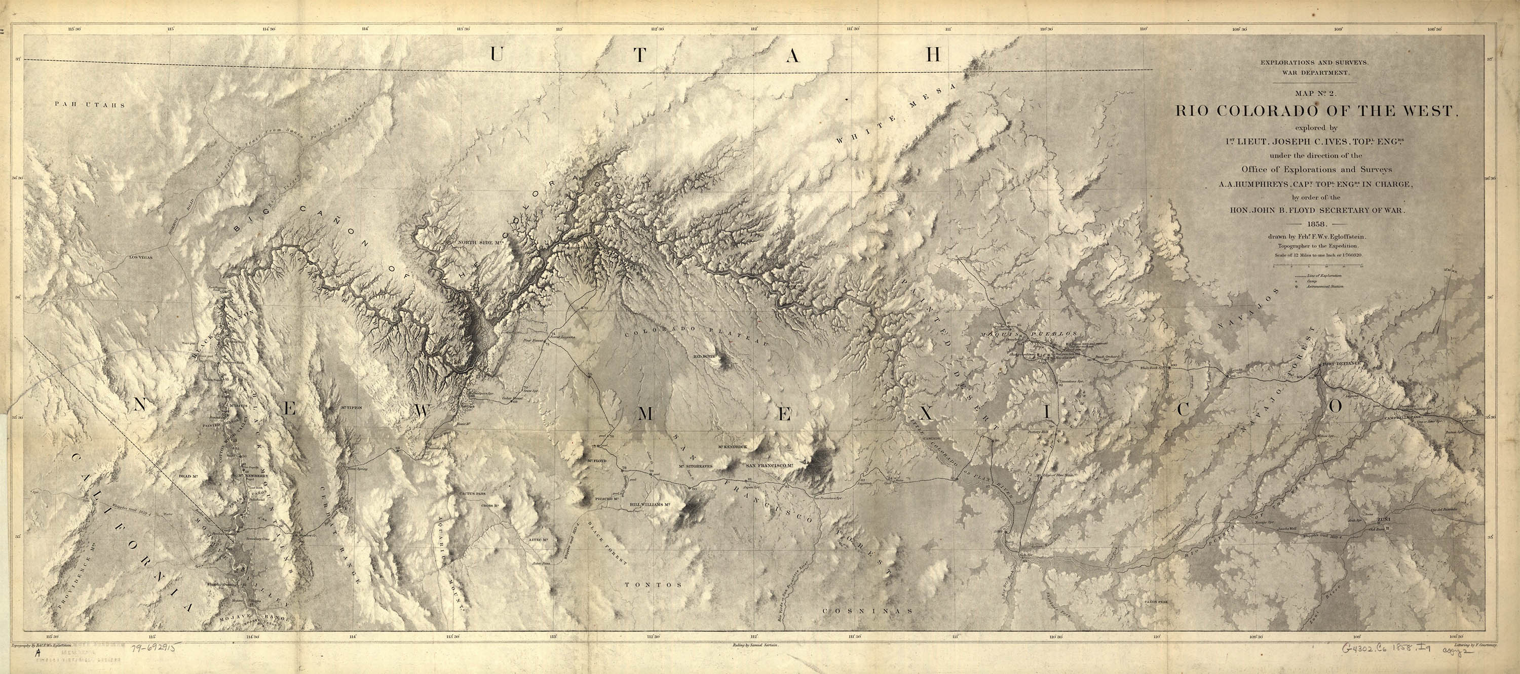
This detail of the Colorado River, centered around the Grand Canyon, was produced by Frhr. F. W. von Egloffstein, topographer to Lt. Ives 1857–58 expedition. In an interesting decision, Egloffstein chose to use shading instead of hatchures and created not only the first tolerable outline of the Colorado and the Grand Canyon, but a cartographic work of art. Here is the hand-colored geological version of the map prepared by J. S. Newberry, geologist to the expedition:
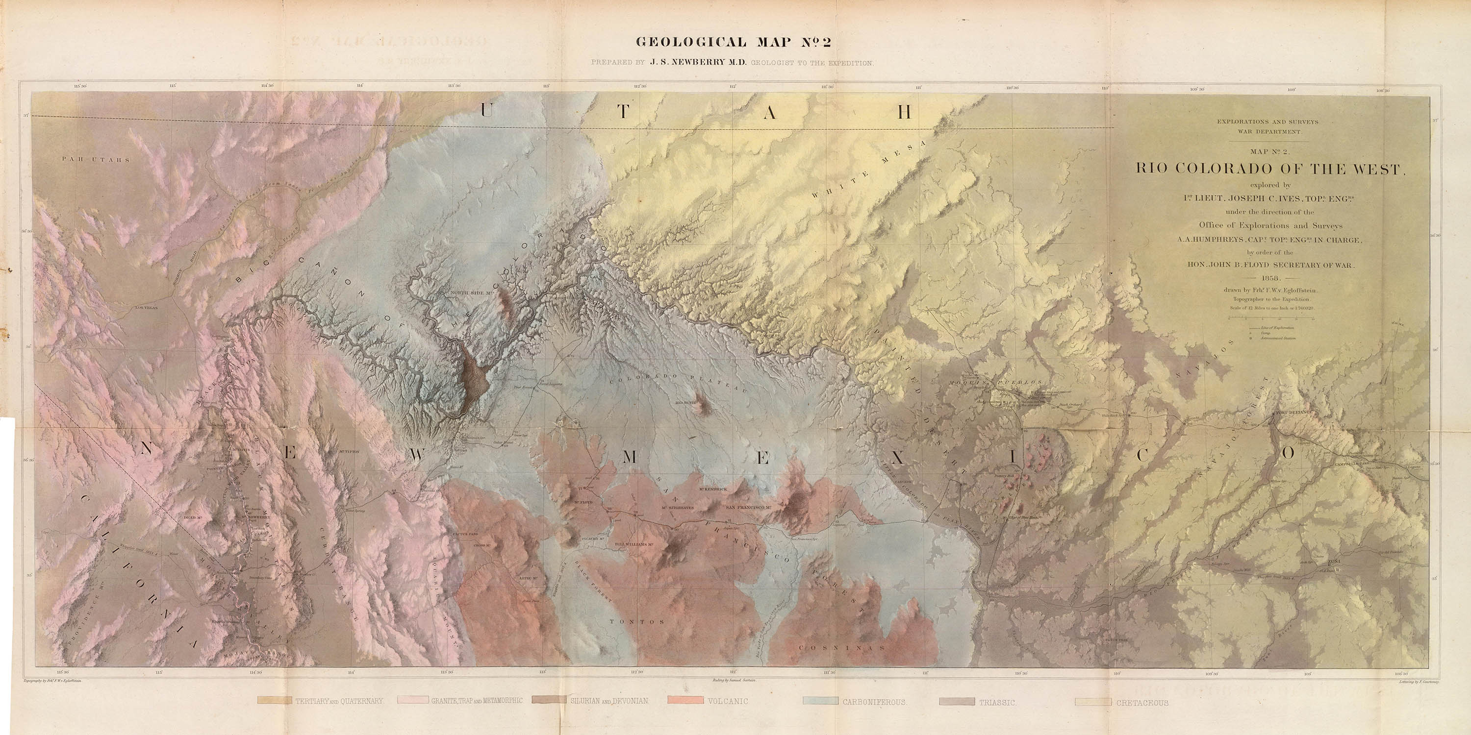
Geological map no. 2, 1858, Rumsey Collection
The Colorado River, from its headwaters in the Continental Divide to its mouth in the Gulf of California drops some 10,000 ft in elevation over its 1450 mi length. Over the last 17 million years this constant flow of water has eroded the rivers banks into epic geological formations, the most spectacular of which is the Grand Canyon – a 277 mi long, 4–18 mi wide and 6000 ft deep rift in the Colorado Plateau.
In 1540 the Conquistador García López de Cárdenas was the first European to reach the Grand Canyon and in 1776 Francisco Dominguez and Silvestre de Escalante crossed the Colorado. For the most part, however, the European explorers simply avoided the remote area and never attempted to map it – that job would fall to later American explorers.
Between the 1803 Louisiana Purchase and the 1848 Gadsden Purchase the US underwent a remarkable territorial expansion – from the Mississippi River all the way to the Pacific Ocean. The migration West, accelerated by the discovery of gold in California, resulted in desperate need for surveys and more accurate maps of these new Western territories.
In 1850 the War Department began a series of Western surveys attempting to find a route for a transcontinental rail line. Along with these surveys Sec. John Floyd authorized an expedition by Lt. Joseph C. Ives1 up the Colorado River to determine its navigability.
Ives and his team, aboard the ill-suited 54-ft steam boat Explorer, set out from the mouth of the river in Nov 1858 and over the next three months reached as far north as Black Canyon where their boat was destroyed. They continued the expedition on mule to Ft. Defiance. In his 1861 report, which included Egloffstein's map (above), Ives commented that the Grand Canyon “looks like the Gates of Hell. The region ... is, of course, altogether valueless.”
In May 1869 and again in May 1871 the legendary one-armed geologist, explorer and Army veteran John Wesley Powell lead expeditions down the Colorado. In his second expedition he became the first to navigate the entire river. Although his expeditions didn’t produce a map, his report and hundreds of stereo views popularized the area and set the stage for future surveys:4
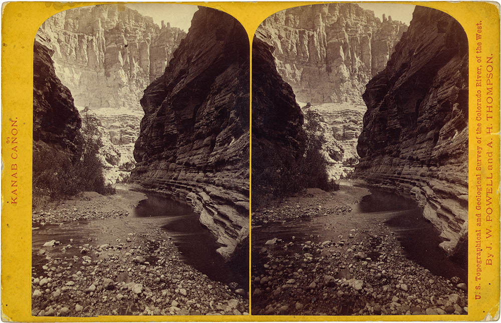
John Hillers, View down the Canon, 1873. LOC
In 1871 Lt. George M. Wheeler, as part of his surveys west of the 100th meridian, began a 33-day scientific and topographical expedition up the Colorado. His map from the expedition, one of many in the “Wheeler Altas,” was the first to accurately chart the course of the river:5
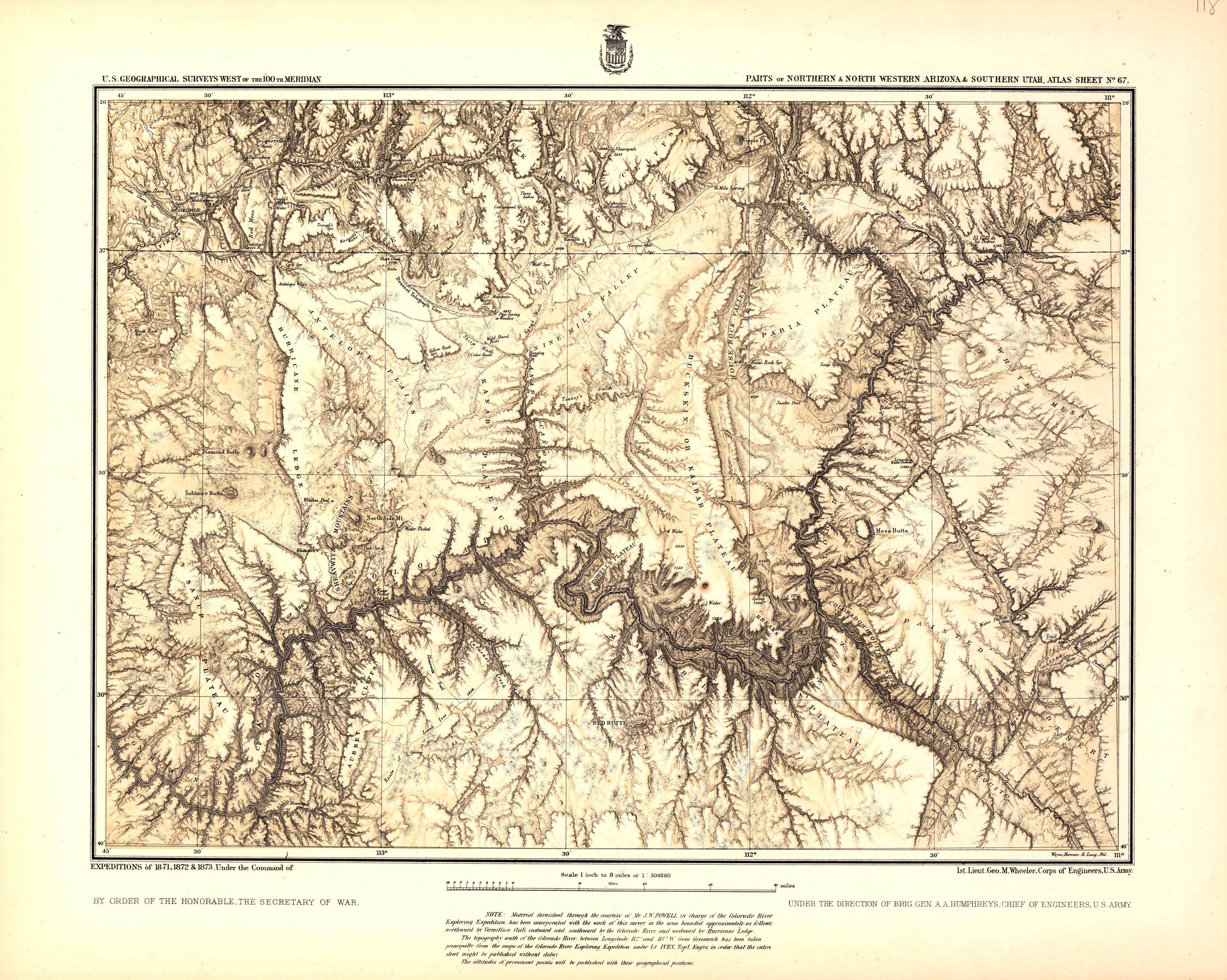
George Wheeler, Altas Sheet no. 67, 1873. LOC
By this time there were four separate surveyors in the West and they were starting to get in each other’s way. In 1879 their efforts were combined into a new civilian agency – the U.S. Geological Survey (USGS).6 The USGS’ first publication was, of course, a geological survey of the Grand Canyon.
Clarence E. Dutton began working on his geological description of the area while he was a member of the Powell survey. His report, The Tertiary History of the Grand Cañon District, published in 1882, included a 23-sheet altas summarizing all of the topographic and geologic information of previous surveys.7 It stands as the first great work devoted to the Grand Canyon:
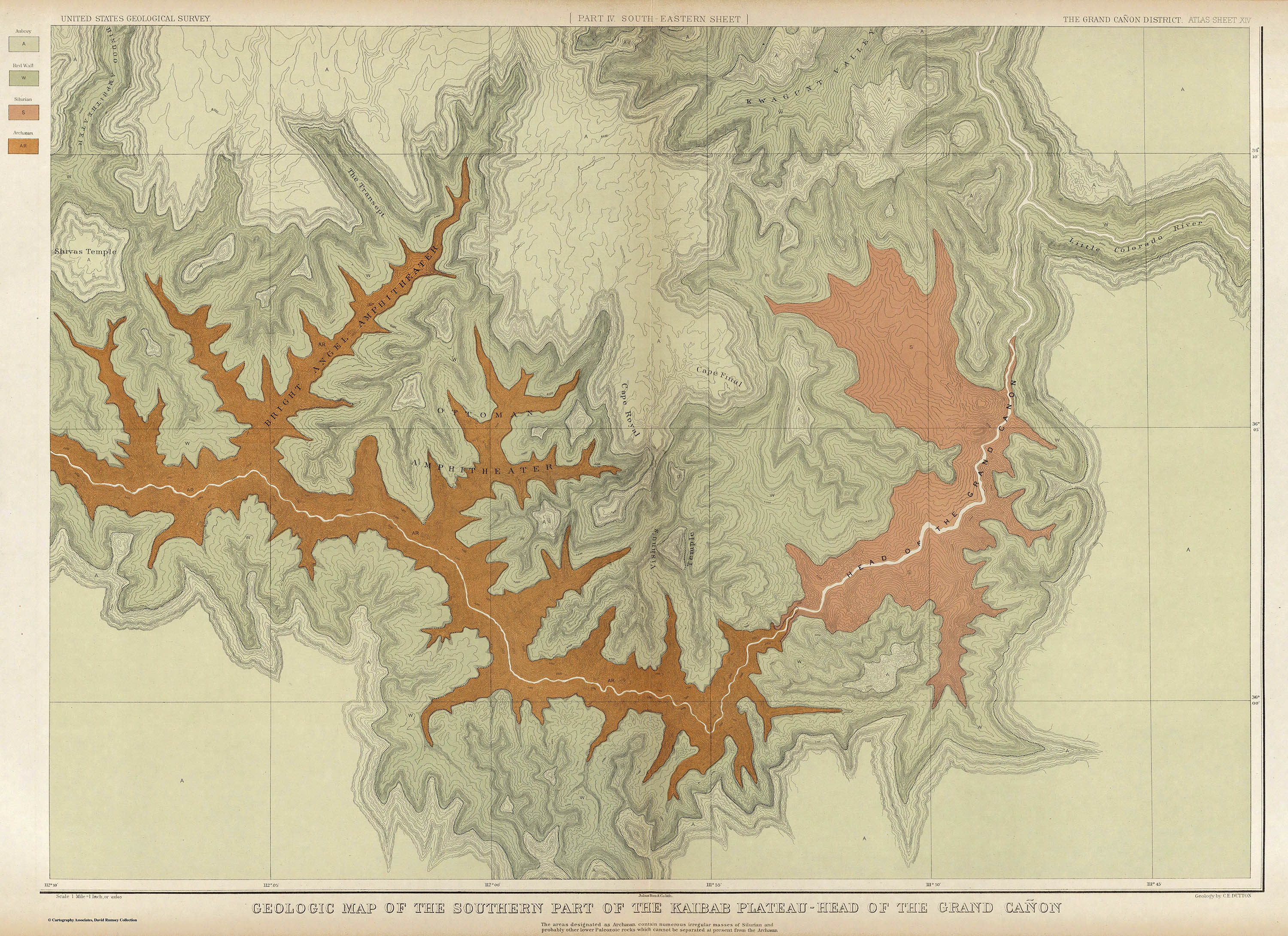
Clarence Dutton, Geological Map of the Southern Part of the Kaibab Plateau, 1882. Rumsey Collection
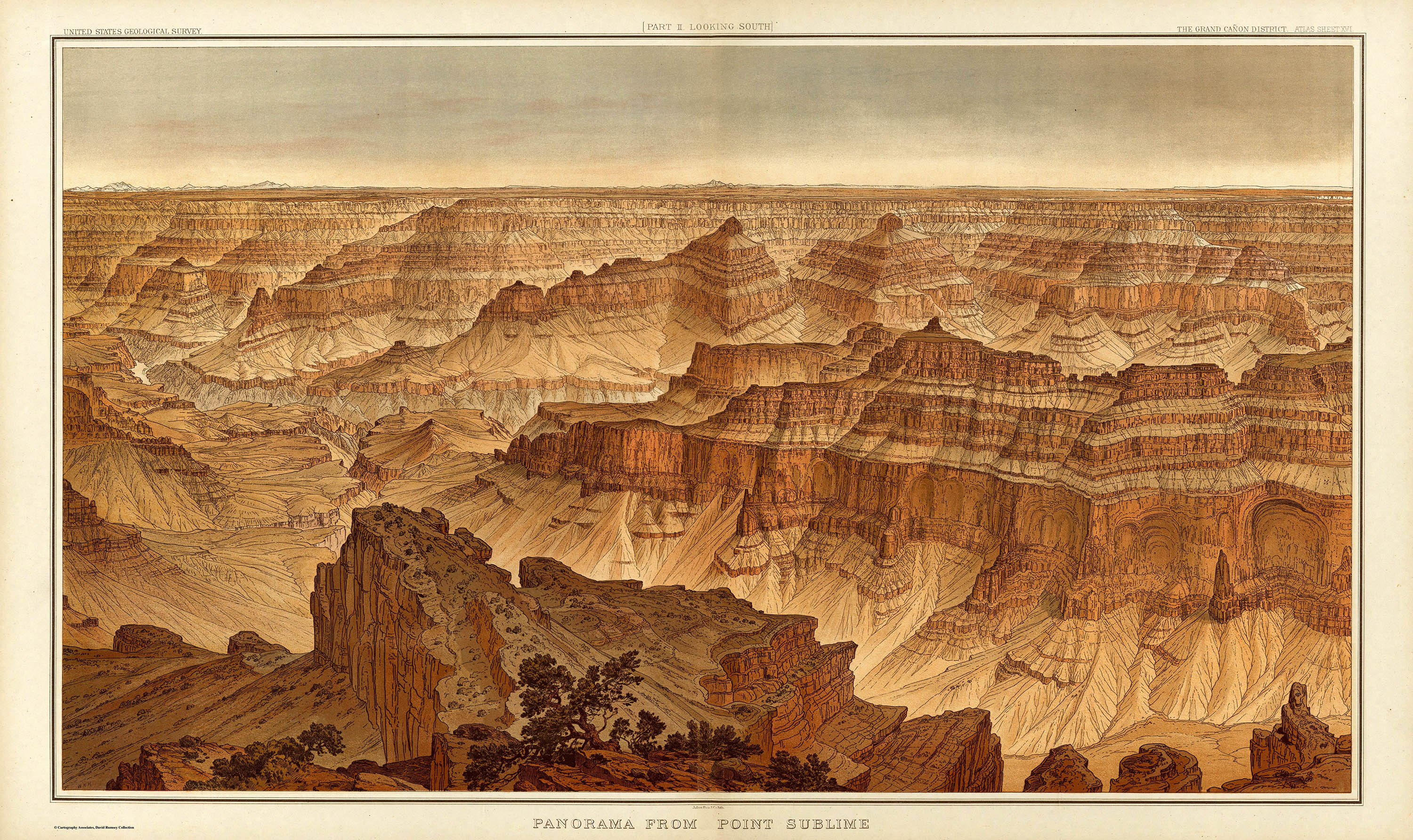
Clarence Dutton, Panorama from Point Sublime, 1882. Rumsey Collection
In 1923 the USGS sponsored their last epic expedition down the Colorado. Between 1 Aug–19 Oct 1923 Claude Birdseye, chief engineer and Roland Burchard, topographer, created a unbroken level survey of the entire river from Lee’s Ferry to Needles, California.
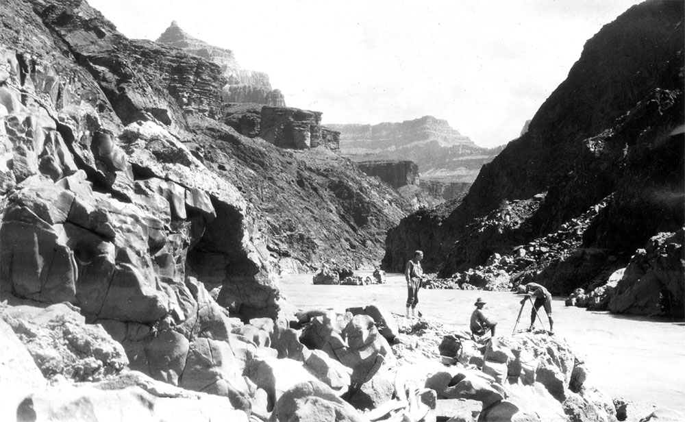
Detail: Stabler (lt), Buchard and Birdseye (rt) below Walthenberg Canyon Rapids, 1923. USGS
Their results, published as 14 maps and seven elevations in the Plan and Profile of Colorado River was the first complete chart of the river.8 Some eighty years later the Birdseye maps are still the basis for every river-running map, chart or guide:

Plan and Profile, Chart C, 1924. The annotations are by Bucherd. Cline Library
1. Joseph Christmas Ives (1821–1868) trained as a cadet at the Military Academy. After a career in the Office of Explorations and Surveys he resigned his U.S. Army commission in 1861 to serve in the Confederate army, where he rose to the rank of Colonel and served as an aide-de-camp to Jefferson Davis.
2. Ives, Joseph C., Newberry, John Strong. Report Upon the Colorado River of the West: Explored in 1857 and 1858. Washington: United States Army Corps of Engineers, 1861. The entire report as available on Google Books.
3. For a short biographical sketch see: “John Wesley Powell: Soldier, Explorer, Scientist,” In Geological Survey 74-24. Washington: Dept. of the Internal Survey, 1976. which is available at the USGS site.
4. Powell, John. Exploration of the Colorado River of the West, and it’s Tributaries, Explored in 1869, 1870, 1871, and 1872. Washington: The Smithsonian, 1875. The entire report is available on Google books. The LOC lists 324 stereo views from the expedition.
5. Wheeler, George. Preliminary Report Concerning Explorations and Surveys Principally in Nevada and Arizona. Washington: Government Printing Office, 1882. Which is available on Google Books. The LOC lists hundreds of O’Sullivan’s photographs from the expedition. The Rumsey Collection shows several composite maps from Wheeler’s Altas.
6. For more about the history of the USGS see: Rabbitt, Mary. The United States Geological Survey: 1879–1989. U.S. Geological Survey Circular 1050. Washington: USGS, 1989, which is online at the USGS.
7. Dutton, Clarence. The Tertiary History of the Grand Cañon District. Washington: USGS, 1882, which is online at Archive.org. The plates are available at the LOC or the Rumsey Collection.
8. Birdseye, C. H., Burchard, R. W. Plan and profile of Colorado River from Lees Ferry, Ariz., to Black Canyon, Ariz.-Nev., and Virgin River, Nev. Washington, D.C.: USGS, 1924. For the importance of Birdseye’s maps see: Quartaroli, Richard. “Evolution of the Printed Colorado River Guide in Grand Canyon, Arizona” in: Anderson, Michael F.A Gathering of Grand Canyon Historians: Ideas, Arguments and First-Person Accounts. Tucson, University of Arizona Press, 2005, which is online at Grandcanyon.org.
1 Apr 2011, updated 5 Apr 2011 ‧ Cartography